
Wind update: not looking too bad this afternoon and evening!
Wind update: not looking too bad this afternoon and evening! Just wanted to share. Might get blustery in any case -
Wind update: not looking too bad this afternoon and evening! Just wanted to share. Might get blustery in any case -
Next storm hot takes and a recap of the Bob Cyclone…
Slide 1: Friday on the ECMWF (euro) - wind gusts Slide 2: Friday wind gusts on the HRRR Slide 3: Friday wind gusts on the NAM
South end fared ok on the last system. Mainland was hit much worse than most expected, although I honestly had no idea how it would all shake out, other than the regular easterly wind haunts (which went above and beyond). As of this morning most of PSE’s customers on the mainland remain without power.
Usually it’s the island without power! Although I feel like we are a much more resilient lot out here, most of us with generators and accustomed to being offline for days.
Feeling for the mainlanders today.
What’s next? Good news and bad news.
Bad news—We have one more to go! Friday we deal with a shortwave looking like the little brother of the Bob Cyclone.
Good news—if you trust the euro and GFS, it’s not looking too windy. Which is great. Rain will be falling Friday!
Bad news (and good)—HRRR and NAM models think we’re gusting to 50. These models didn’t do well on the Bomb cyclone for south whidbey. They over estimated our wind speeds by about 25mph.
These models did estimate the cascade foothills correctly however.
My take - we will need to keep an eye on the upcoming shortwave today and verify the track stays well offshore (slide 1) Friday. I’m trusting the euro and hoping it stays a nothingburger. BUT - I would also be open to the idea of high winds on Friday around noon.
Will update us tonight on where this is shaking out.
Would love to see 0 impacts from Bob’s brother, just to give the mainlanders a chance at getting back online tomorrow.
#wawx #southwhidbey
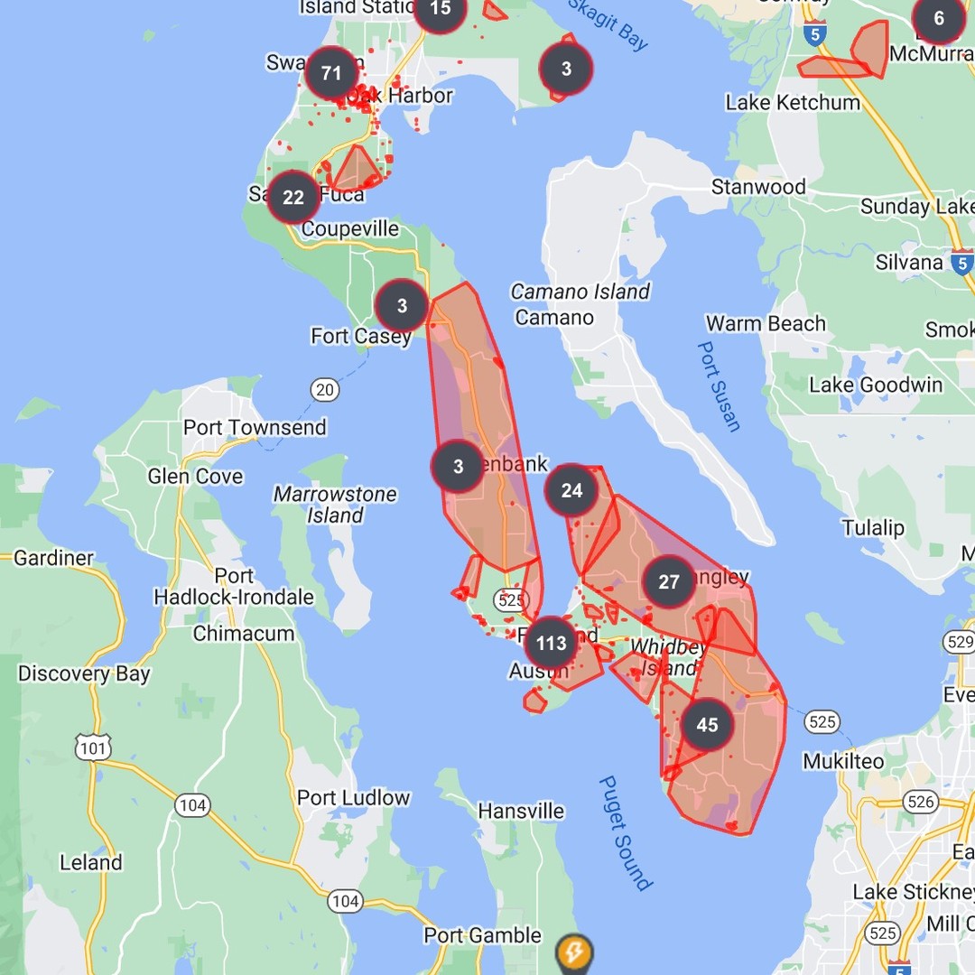
Recap time and what I’m seeing… Still some outages mainly around cultus bay road and up on Crawford. Looks like the outages in Langley and Saratoga areas have been restored which is nice… and although our lights flickered endlessly last night we never actually lost power (bayview area).
Generally we caught a break, compared to the mainland, and it seemed that the upper atmosphere carried the bulk of the vacuum east wind into the big system without too much mixing down to the surface.
I’ve been tracking another system for Friday evening but wanted to get through the night before I let everyone know.
Possibility is there to get windy, but still a bit early to tell. Will update!
How’d it go for you? We had some gusts to about 40 here but it was generally mellow. The HRRR and NAM didn’t really play out for us.
Let me know in the comments 💜
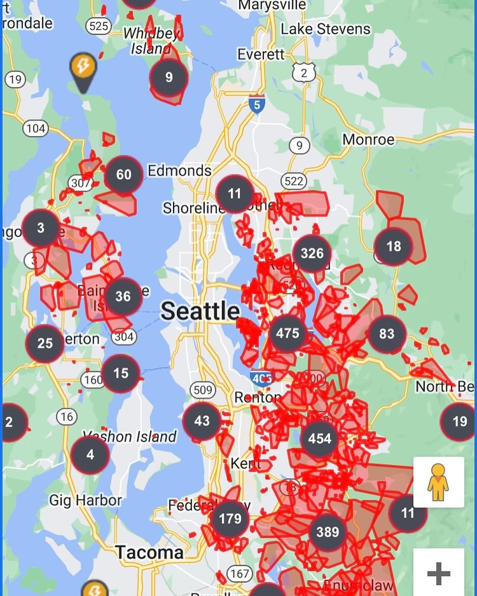
Holy moly that’s a lot of outages! #lowpressure #mountainwave #gapwinds #wawx
Update #3 ⚠️⚠️⚠️ — not liking the model disagreement on Tuesday evening. This is a red flag 🚩 to me.
Yesterday I said I wouldn’t be surprised if the system was “mellow” for us compared to other areas, but with both the NAM and the HRRR throwing 50MPH+ gusts from the east/southeast I am trending my thinking into a situation where we may be seeing a possible major impact to many puget sound lowland communities, including south whidbey.
The European model does not agree with the NAM and HRRR, paints us to 42MPH gusts.
Something about this storm just doesn’t sit right with me.
Will revisit tonight, but now would be the time to understand that a multi-day power disruption is not out of the question here.
This will be the lowest pressure storm in recorded history off the coast of Washington.. these weather models are built on past data. At some point we get into uncharted territories when a 942MB low has entered the chat. Luckily she is staying well offshore.
Will post a few more updates to this storm today and tomorrow! Not a bad idea to keep an eye on official sources from here on.
#wawx #whidbeyisland #southwhidbey
Update 2 ⚠️ Tuesday is still looking historic in terms of pacific coast weather. What’s the impact to our zone? Hopefully not much!
However… potential is there for things to get a little dicey. I’m doing the regular “prep” stuff on Tuesday: topping up on gas and propane, staging the headlamp, securing stuff in the yard, grabbing snacks and candles from the store - all that.
This is not the Columbus Day storm or anything close to a proper “blowdown” by any means.
It’s important to understand that the core of this storm is not making landfall and will stay well offshore in the pacific.
That said — We’re not risk free here.
Models are touching 40-50mph of wind Tuesday evening, which can be ok for us — but it’s a weird direction.
East-southeast is not normal here and some trees may be struggling to stay rooted.
I’m not convinced there won’t be power outages.
I also wouldn’t be totally surprised if things ended up “mellow” here compared to Mt Vernon, or say, south Seattle. Areas that reside closer to the known gap wind channels and passes.
Wind Timing: Tuesday around 3-5pm we start getting windy. Peaking probably around 10pm- 1am
Non-local impacts: Northern California will likely make national news for rain and flooding. Some areas there may be seeing historic water levels as the tail of this behemoth, historic storm creates a massive atmospheric river aimed at the Mendocino / Humboldt areas and extending to the I-5 (Siskiyou).
And the waves! 35feet! Just massive waves on the coast. Incredible 🌊
Looking forward to capturing some cool satellite images this week!
Again - not thinking we’ll see much impact - but as always I may be wrong 😑
#wawx
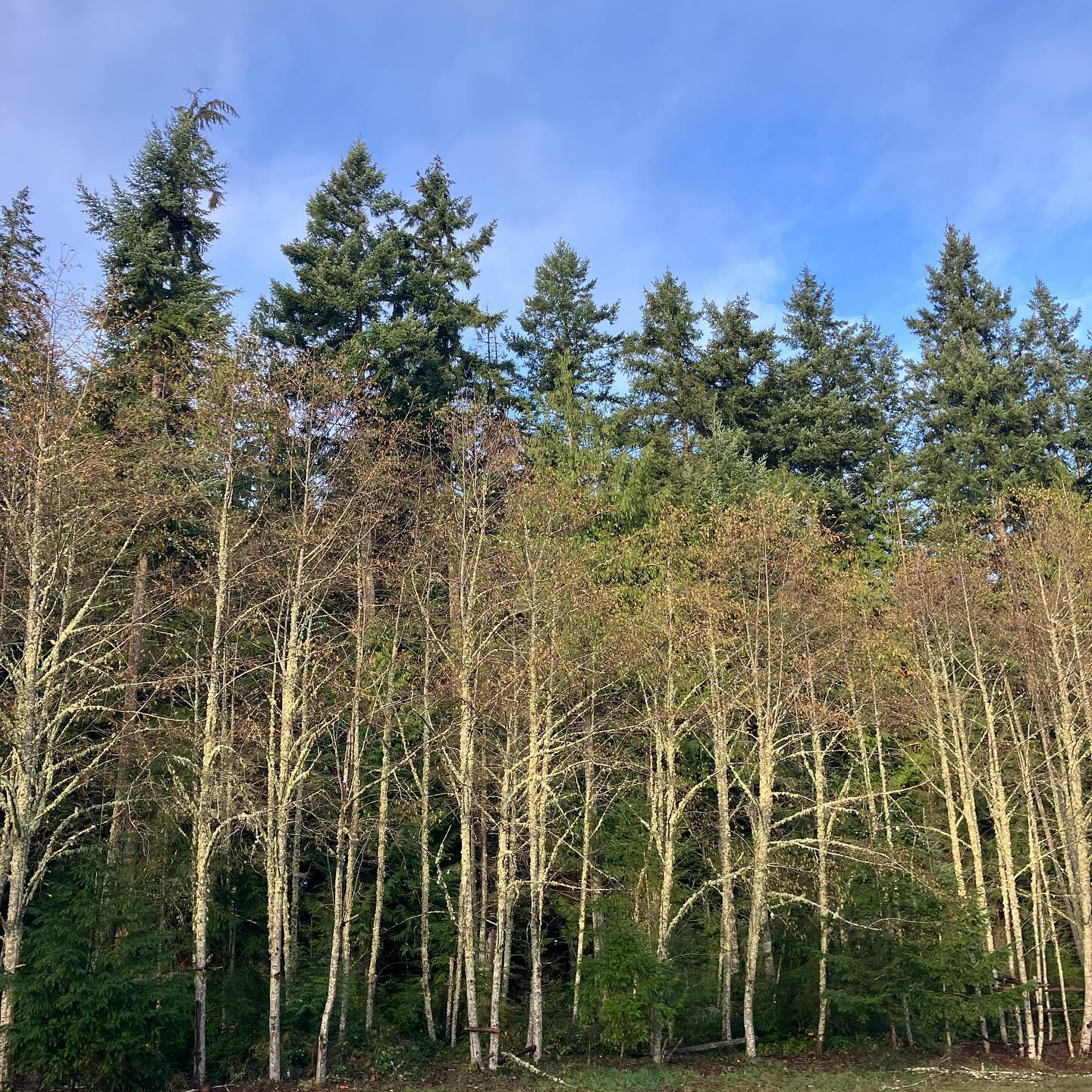
A scenic day between storms today! At one point the sun was out and the wind was absolutely flat, not a bad time to be out on the lake :)
Tomorrow and Sunday we’re looking at a cooler system off the gulf, very cold air aloft, but I’m not seeing impacts although it does look blustery and showery out of the south tomorrow and Sunday.
Tuesday! – Tuesday is another story.
Check out the absolute beast of a storm offshore Tuesday. ECMWF is seeing gusts up to over 100mph off the coast! 🌊🌊🌊🌊
Locally: gap winds Tuesday as easterlies will be compressing and funneling through the cascades as the storm bottoms out off shore.
Cascades backcountry, hurricane ridge, stampede gap, columbia river gorge will all be ripping winds – but we actually fare pretty well on gap winds. The direction can be challenging but it’s not looking over 40mph at this point.
Will update if this changes tomorrow.
Will be fun watching this one - expect impacts to Oregon and the coast - if you have interests in those areas, keep an eye on this storm.
Looks like the atmospheric river off this storm will be notable as well, mainly impacting northern CA #wawx
Hi friends. The second storm is knocking on the door this Tuesday afternoon. I was checking back in on the predicted wind speeds, and the models are all over the place a bit.
Wind Gusts: Euro: 30MPH HRRR: 55MPH NAM: 44MPH
I’m still confident in my earlier post where I anticipated this would be a non-event for the south end (albeit blustery).
However, the chance is there that overnight tonight we may see a some nuisance power outages. I don’t expect anything but localized trees down, not an island-wide event by any means.
Gusts will be out of the south. For our trees, they are generally rooted and accustomed to strong southerly winds as this is the prevailing winds for winter storms.
San Juan’s will be another story in terms of wind speeds. Much windier up there.
BIG snows in the mountains! Hopefully we aren’t seeing any major pineapple expresses after this and we stay cold for maximum skier and snowboarder stokage.
#wawx #southwhidbeyweather
Couple bug chonker gulf of Alaska lows are coming for us this week. Back to back. No major impacts on the island - but the veteran’s holiday and week following will be rainy and blustery at times (from the south). Locally we’re looking rain-shadowed but there may be extended periods of rain sun/mon and again Wednesday.
These storms are looking like prolific snow makers for the cascades and Olympic mountains above 4000ft. Winter storms and lowland rainz, if you’re venturing over the passes there may be some delays!
Thanks always for reading. Extended forecast is looking wet!
By some act of God apparently we are one of a very few amount of people on the south end with electricity? (probably not for long…)
Wind is actually mellow here with occasional gusts to 35 – but I’m looking at the “Sierra Bluffs” Davis weather station at Libby Beach and it just clocked a 67MPH gust.
#wawx
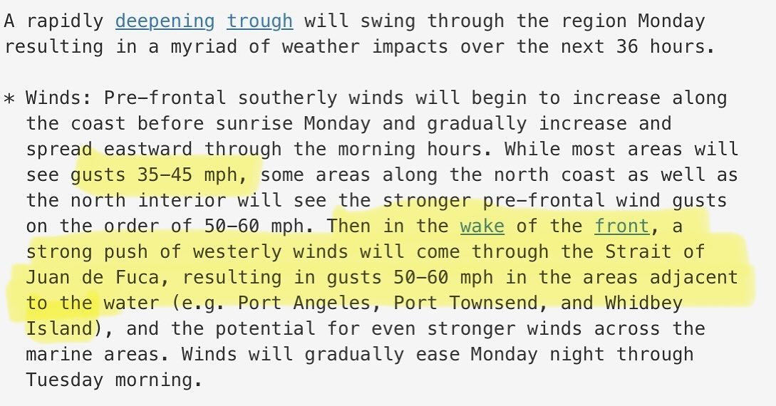
Update #3: NWS Seattle has entered the chat! First official wind advisory/warning I’ve seen from them for this Monday system — although they did have some SCAs and gale warnings up previously for Admiralty Inlet.
Not much has changed in the models. Wind party starts around daybreak. This will include rain - seemingly of the sideways variety. Rain ends, and then the westerlies go nuclear down the strait.
Good time to fill up the tanks, grab what you need from the store, dust off the gen, and drop off that ballot..
Waiting for the latest model runs tonight but NWS flying a wind warning is notable so thought I’d share ✌️
Update #2: ‼️ the latest ECMWF is making a thesis about us starting Monday with south winds stronger than previously expected, now she’s saying gusts approaching 45mph on the south end around daybreak Monday. Big westerly surge still anticipated for OH north. Likely some impacts later from westerlies down Saratoga into Langley town
My previous post has additional info on the Monday event.
Tomorrow we get more data from the NAM and the HRRR - will update as we go..
🌬️🌬️🌬️🌬️🌬️🌬️🌬️🌬️🌬️🌬️🌬️🌬️🌬️🌬️
‼️‼️ Wind Storm Monday: A weekend of calm winds, cool temps and light / moderate rain before things get wild on Monday.
Latest guidance suggests we’re waking up to blustery south winds Monday morning, as a powerful late-breaking system begins to make its way closer to Vancouver Island.
Expect the strongest winds of the season as a westerly surge down the strait puts Oak Harbor into the crosshairs for possible 65MPH gusts Monday afternoon.
Many things to observe and refine over the weekend on this storm — but models are currently showing south whidbey with about half the wind speeds of what’s coming down the strait for Oak Harbor north.
A blustery scene here in any case, and I’m not expecting the electric system to fare well for us being that we’re depending on the northern lines for our grid.
Also the westerly surge events are typically strongest down Saratoga passage into Langley proper.
Will post updates to this event over the weekend.
Peak of the surge down the strait is looking to be about 2pm Monday afternoon. Wind will be strong out of the south beginning in the morning and shifting west northwest as the low passes to our north.
More to come! 🌬️ 🌬️