A potent system tonight headed directly for Haida Gwaii. A 970mb low is by all means a very powerful storm, typical for November but if one of these decides to drop a bit south it would make for an interesting weekend..
November keeping us on our toes here.
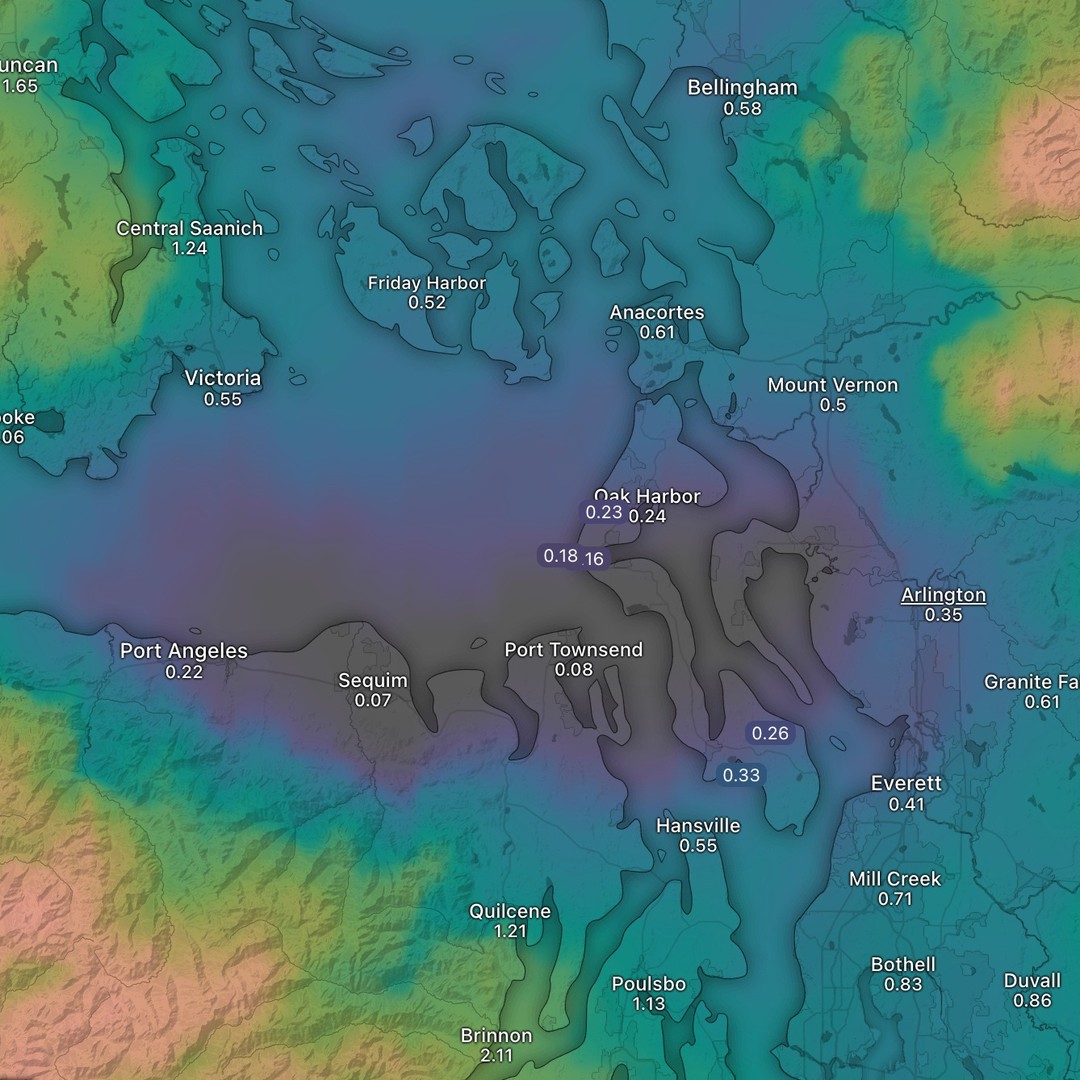
Last slide illustrates our rain shadow perfectly. Expect gusts to 50MPh during this event Saturday. Models have been underdoing the winds during the last few storms.
The cold, dry, and sunny period is officially coming to an end today. The cloud shield will increase today and rain likely begins late this afternoon, and Thursday we are beneath the first of 3 pacific storms.
Thursday, Saturday and Monday are the storm days so far. Tomorrow’s storm looking breezy, but we should be staying below the 40MPH threshold.
On the extended the subsequent systems all appear to stay under 50MPh on winds, but the Monday storm in particular will need to be watched closely for stronger gusts.
Some rain shadowing is expected as these systems approaching us from the south southwest and getting mostly absorbed by the Olympic Mountains.
South Whidbey looks good for just under an inch of rain on the Thursday system.
Hoping to get a weather station setup at the house soon! Will update on the Saturday and Monday storms as we go.
Monday - similar to today. Cold and dry with morning frost likely.
🎃 Tuesday 🎃 - previously mentioned pattern change begins – looks like we may have some high clouds streaming in through the day. Trick-or-Treating looks favorable, temps around 52F - looking dry!
Wed / Thurs - At some point (looking more like Thursday) we’ll have a system from the SSW. Warmer and wet. Monitoring the wind, but gusts looking to be around 40MPH (will need to check back on this system)
Friday / Weekend - a second system forecast to approach, timing still getting dialed on this too.
November ya’ll - dust off that generator - the ensembles are already printing windstorms. Nothing in agreement yet but seeing the odd 2 or 3 out of 50 models with those big big gusts means things could be getting weird. 😅 😜
First screen grab is showing current wind speed at about 30,000ft. This is illustrating a typical setup for colder temps at the surface for puget sound.
This jetstream is also associated with a “polar lobe” so you can imagine in this setup how cold, arctic air is transported over the inter-mountain west, across the continent and into our maritime northwest.
This setup is similar to what brings snow down to sea level in puget sound - with one difference - the polar lobe will be further west, and cold air will spill off the continent around Haida Gwaii, mingling with warmer, moister Pacific air. This results in a storm building and wrapping back into the maritime northwest. That’s basically why we see occasional snow storms at sea level here on Whidbey. That’s the setup.
Second slide - the upcoming jet setup for the second half of this week. Quite a difference here from the first. This is a more typical pattern for us during fall and winter.
This setup will transport warmer air (and storms) into the region, but these storms will be noticeably warmer compared to the first slide pattern.
The second setup will also throw the Gulf of Alaska Low into storm mode, and here we’ll see a return of seasonable temps (lows in the 40s, highs in the 50s or 60s), but also clouds and rain.
We’ve still got some cold temps to get through this weekend and early next week, but the pattern shift is coming.
One trade off, however, is we may lose that warm afternoon sun, but I’ll be evaluating the storms for next week and give more detail on what happens with the Gulf of Alaska low and what it will bring for us.
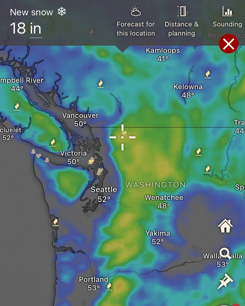
First winter storm of the year currently making landfall. Heavy rain in the lowlands currently. This will be shifting to a more showery situation as the low progresses through on Wednesday. We’ll see another shot at rain Thursday when this low wraps around before pushing south. Weekend is looking dry and cold. Overnight temps this weekend will flirt with freezing here on the south end. Off-island (Everett / OP) will likely be seeing the first lowland freeze of the year Sat / Sun nights.
Looks like a couple feet of fresh snow incoming for the Cascades and the Olympic mountains this week. Temps on the island will be lower this week, looks like Wednesday our high will be around 45F.
Tuesday afternoon and evening into Wed morning looks the wettest in terms of rain.
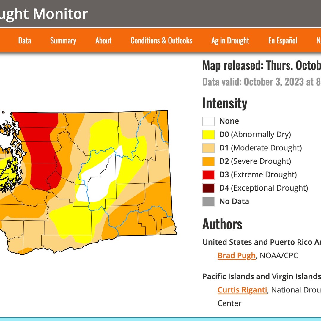
Great seeing the snow for the mountains, hopefully we are making progress on the extensive drought situation in the region.
No wind events expected, but the Tues/Wed system has us breezy to 25MPh -
Slide 1: Clearing the remaining clouds on today’s satellite view… Thursday and Friday looking nice! Certainly drying out and maybe tapping 70F if we’re lucky?
By Saturday morning we return to a cooler / cloudier / wetter period for the weekend. That system is weakening, but we’ll be dealing with clouds, some rain, and breezy south winds. “Sweata weatha”
Slide 2: It’s been calm here so far, but clearly the North Pac is not messing around…
Take a look at that storm bearing down on the Aleutian Islands tonight!
Slide 3: current wave heights on that AK storm.. just an absolute unit of a system up there.
Slide 4: projected wave heights for another massive system developing, this is one expected to form from the remnants of super typhoon Bolaven, which will amplify the already busy storm cycle in the North Pacific.
Models disagree on where that extra tropical system will make landfall, but it’s looking like it will swing up into AK.
Still some chances at an Atmospheric River event for Sunday… but as of tonight (Wed 10/11/23) the models can’t agree on that.
Stay tuned for updates on next week’s weather. The models need time to agree 😉
Now that we got that earthquake out of the way – let’s break down this week’s weather…
Today’s satellite view shows the next system making landfall tonight, and will bring us into a stormier - albeit “rain shadowed” period through Wednesday. (There’s another system developing behind the one in the video)
Thursday and Friday we have a shot at some beautiful days before a possibly wetter system over next weekend.
Will update on that system later this week. Temps will be much cooler by Tuesday.
#wawx
Today (Saturday) we get another nice day before we dip back into a bit of rain chances. After Tuesday we rapidly increase the chances of warm weather with models agreeing on a ridging over the northwest (the red in the loop = sun / dry, blue = rain and clouds).
Much remains to be refined on whether we get heavy fog sneaking under this ridge (locally)… But for now the chances of warm weather next Wed - Sun are increasing!
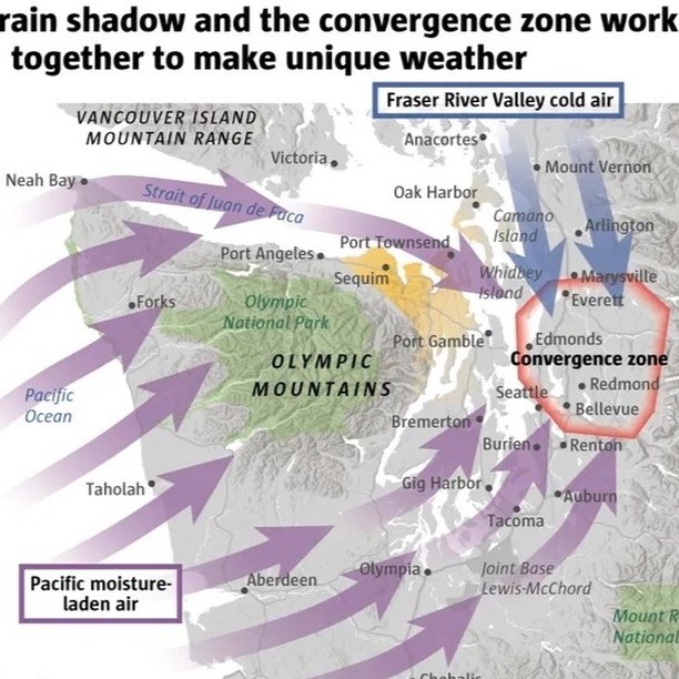
Phenomena somewhat exclusive to the south end of Tscha-kole-chy (whidbey island) is what weather folk refer to as “the convergence zone” or the PSCZ. Today’s loop has an example of it, albeit weak, but wanted to point it out tonight.
These will often form during the final days of a storm cycle, after the main event is swept east. If you happen to drive up to Anacortes or Oak Harbor, you’ll sometimes find sunny / breezy conditions up there, only to drive back south into heavy rain and clouds.
The zone often drapes across us toward Mukilteo/Lynnwood and then can meander south toward Tacoma, creating a line of precipitation (or snow), depending on the conditions.
This can sometimes create radical differences in snow and rain totals in the area.