Exciting announcement for 2025 🎉

Exciting announcement for 2025 🎉

Exciting announcement for 2025 🎉

I’ve got a big announcement to share! First a quick backstory…

Over the past few years posting to this account, I’ve had issues with the algorithm where I’d aim to inform the community about a weather event and some followers would see the post 3-5 days after I’d hit the share button, while others saw it immediately. Not a great experience. 😔

This whole “feed” issue is super annoying for someone who depends on getting content out in a timely way, sometimes up to the hour!

I’ve also experienced some posts being “boosted” by meta while others were seemingly hidden! 🫣

So I set out to create a website where I controlled the content, and this also makes my content available to people who aren’t on this platform! 😁

So… drumroll please 🥁 — I am pleased to present the newest south whidbey community website and the first weather blog dedicated exclusively to our unique microclimate:

southwhidbeyweather.com (link in bio)

And… there’s more!

You can sign up on the site to get a morning email summary of any posts I make. So even if you miss a post on IG, you’ll have it in your email inbox!

Never miss another windstorm! 🌬️

I’ll still be posting all content directly to IG… And for the technical folks out there, I wrote a script that generates a blog post from my IG content, which is kinda cool 😜

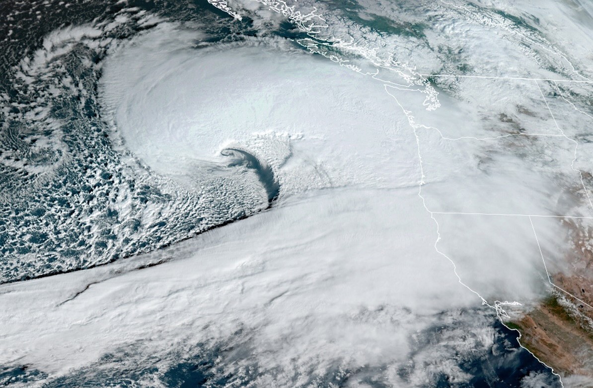
Taking a look tonight at the GOES satellite of that late breaking storm - check out the end of the first clip, you'll see the system just beginning to break away from the main AR and spin up toward the coast.

Taking a look tonight at the GOES satellite of that late breaking storm - check out the end of the first clip, you’ll see the system just beginning to break away from the main AR and spin up toward the coast.

Thursday AM could get a bit spicy when this thing comes to visit.

Second clip zooms out to show the extent of the current atmospheric river, which at one point stretched from Washington to Taiwan! 🤯🤯🤯

#earth #weather #wawx

Friday AM: baroclinic late breaking wave will hit the state.

Friday AM: baroclinic late breaking wave will hit the state. This can have major impacts for our region.

Believe it or not we have two storms to get through before this sucker punch of a storm rolls through.

European shows the low passing directly over whidbey, which actually mellows out the wind forecast as the bent back occlusion stays south of us. I don’t expect this outlook to hold.

The low moves south or north in the forecast and it’s going to be lines down for us.

The system on Christmas looks blustery for us, and downright windy for Coupeville north.

Wind advisories are up.

Friday storm is the one watch. Could be a doozie folks.

Update to my last post!

Update to my last post! Things are calming down on tonight’s expected system. Looking like the position is tracking more northerly.. Still a vigorous storm offshore but I’m not seeing the east winds trending up. Probably no / very low impact for us with some larger gusts in the cascade foothill communities.

If you watch the reel to the end you’ll see what I’ll be watching next… updates on that to come! Still too far out to get a good idea yet.

I’ve been tracking another monster low expected to be developing on Monday December 23rd offshore.

I’ve been tracking another monster low expected to be developing on Monday December 23rd offshore.

It’s currently looking to be of minimal impact to Whidbey (for now). But wanted to put this out there as most of the models are suggesting a similar situation of the last bomb cyclone in terms of possible region-wide impacts.

Cascade foothill communities, Seattle metro (east side), SeaTac, Paine Field… this wind event looks very similar to the previous one that left many mainlanders without power for a few days… albeit a smidge less windy for the region.

Every storm is unique, so this Monday system will likely have a different personality and not a carbon copy of that last “Bob cyclone”

Will need to update again tonight on what to expect and ensure the center of this low is still expected to make landfall north of Vancouver island.

No end to the active weather on the extended with the north pacific jet-stream seemingly on turbo mode delivering a series of storms back to back basically every day until the end of the 10-day model run.

Rumor has it flights from Japan to SeaTac are arriving 1-2hours ahead of schedule with pilots reporting consistent tailwinds across the entire Pacific Ocean.

Wind advisories are up.

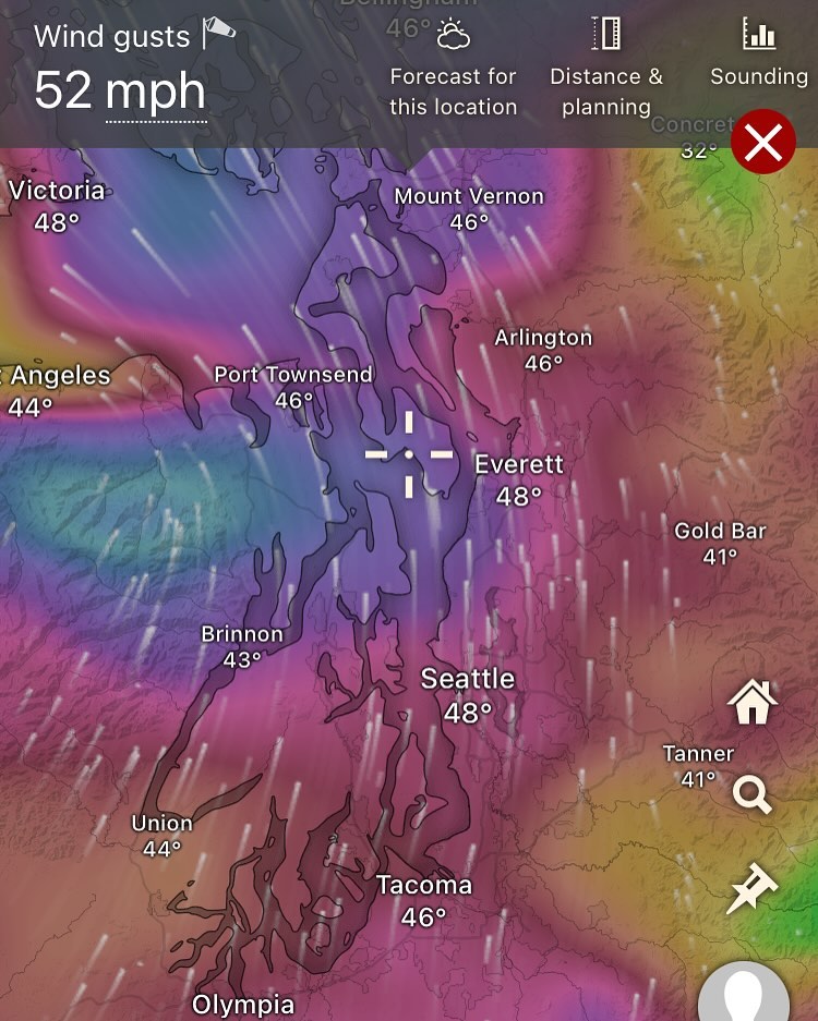
Wind advisories are up. Checking around at some local weather stations and so far so good on gusts.

We’ve got a nice rain shadow going for the moment! This may stay around and keep us sheltered for the night.

At some point we’re expecting a westerly surge down the strait.

Hopeful we dodge this one with minimal impact.

Models have trended our wind gusts down over the last few runs.

I’m thinking we’re waking up to electricity and hot coffee tomorrow over lines down.

My two cents at least..

Now that we got that Fri/Sat windstorm out of the way, you may want to keep that generator nearby as we collectively turn our gaze to Wednesday...

Now that we got that Fri/Sat windstorm out of the way, you may want to keep that generator nearby as we collectively turn our gaze to Wednesday…

Still a bit early to really dial this one in on what will happen but the potential is there for a broader, region-wide wind event, but this could also totally fizzle out and turn into a nothingburger.

The North Pacific is undergoing a particularly active time through the end of December on all the long term models with storm after storm queuing up.

Keeping an eye on this Wednesday system and will update us…

Leave a comment if you enjoy these posts and want to stay up to date.

We’re still on track for a windy Saturday.

We’re still on track for a windy Saturday.

We’re still on track for a windy Saturday. Not out of the question to see some 50mph+ gusts from the south.

Image description

Storm is draping over us now with rain expected through the afternoon and evening (fri).

Winds looking like they’ll be up early around 4am ✌️calming by the evening

In my last post I mentioned “waffling” and this is exactly what I mean…

Posted are the different European model runs on this weekend's storm.

In my last post I mentioned “waffling” and this is exactly what I mean…

Posted are the different European model runs on this weekend’s storm. 

 Slide 1: Tuesday’s ECMWF run. 
 This is what I was seeing when I made my last post sending a bit of a heads up to the south-facing folks..

In this situation, Whidbey would be looking at possibly 60MPH gusts during one of the highest tides of the year. Impactful for sure.

Slide 2: Wednesday’s ECMWF run. 
 Wednesday’s run takes the center of the low into the northern tip of Vancouver island.

A much less risky situation for us.

This would be a blustery day, probably relatively low impact, with winds gusting to around 40MPH. 


Slide 3: Today’s latest ECMWF (12 noon Thurs).
 Today we see some slight tracking to the south, putting the low right into about Tofino, still not the Tuesday situation, but we’re bumping up into higher wind territory today… basically just at the limit of what our local trees and power grid can handle without issues.

Timing: Friday night into early Saturday morning.

Wind looks to wrap up around Saturday evening. 

We’ll still need to watch the next few model runs, if this continues trending south in terms of the low making landfall, it will be the difference between 40MPH and 60MPH situation 

What’s the difference?

60MPH winds exert roughly 2.25 times more force than 40MPH winds!

Put on your math cap and ponder that one for a second. 
 Things aren’t 1:1 when it comes to wind speeds!
 We’re walking a fine line here… 

#wawx #southwhidbeywx

⚠️ Weekend storm is looking interesting today 🤔🤔🤔Tuesday PM update:

⚠️ Weekend storm is looking interesting today 🤔🤔🤔Tuesday PM update:

The ECMWF, the premium weather forecasting supercomputer in the world — and my personal favorite weather model of the bunch, seems to see us getting much more involved with that Saturday / Sunday system than previous model runs.

What does this mean?

South-facing, waterfront homeowners need a heads up and should pay attention to the timing and track of this weekend system.

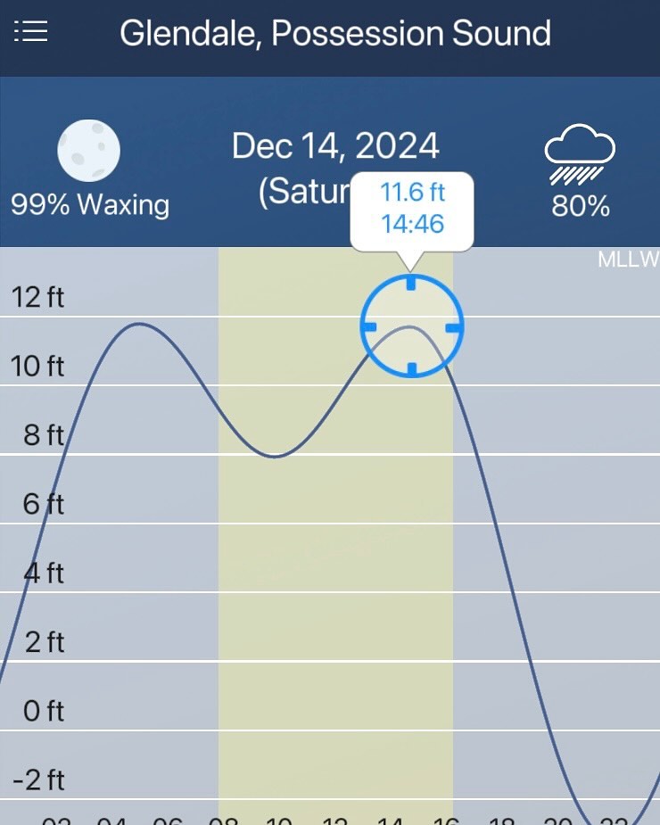
Saturday the high tide is 11.6ft, close to the highest of the year.

We need to keep an eye on these southerly winds and storm timing — if this storm track remains consistent from run to run over the next few days — that combined with the tides ++ full moon 🌕

Some followers I know have south facing interests near the water and will need to be tuned into this storm.

Still a chance the ECMWF waffles on the path — but we have to wait and see. Heads up in any case

#wawx #possession #southwhidbeywx

A high pressure ridge has dominated the weather pattern for the last week, and the pattern looks to continue through most of the current week.

A high pressure ridge has dominated the weather pattern for the last week, and the pattern looks to continue through most of the current week.

A high pressure ridge has dominated the weather pattern for the last week, and the pattern looks to continue through most of the current week. 

High pressure is synonomis with sunny, hot weather in the summers. But during the winters, high pressure, at least around puget sound, is actually associated with fog, chilly temps, and an inversion layer.

All evident this morning with fog creeping into our mornings. 

What’s next? 

Thursday / Friday - we’re looking at finally breaking out of the persisent high pressure ridge that’s been dominating our weather. 

The pattern change is looking wet, with the possibility of some blustery winds.

Possibly an atmospheric river for the weekend? An active weather pattern beyond in the extended. 

Need to dial it in over the week, but expect changes toward the end of the workweek! 

#whidbeyisland #southwhidbey #wawx

A bit more of this on the menu for the next 3-4 days.

A bit more of this on the menu for the next 3-4 days. Calm winds, showery periods, cooler temps (highs in the mid 40s and mid 30s overnight).

The extreme weather seems to be on holiday for a moment, which is good for all. Wednesday looks like a very nice travel day for anyone headed over the passes or down i5.

Not seeing anything major as a high pressure ridge sets up over the pacific at least until Wednesday.

Things can change quickly. This is our stormiest period, and the gulf of AK no doubt will wake up grouchy… but the models aren’t picking up on anything yet.

For now, enjoy this tranquility as much as possible. We all know it won’t last!

#wawx #southwhidbeywx #chill